Wizdom consistently creates websites and solutions that reflect the needs, the personality and vision of our clients. The success of online and offline branding, communications and marketing strategy of your company will always be our goal.
Our team of professionals has the reputation, history and the know-how of the new technologies. We offer quality services at affordable prices.
http://wizdom.gr
Tuesday, 10 December 2013
Google launches DIY street view
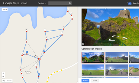
A screenshot of the Google street view editor Photograph: /Google
A new Google Maps feature lets users create and share their own "street view" paths from photos and location data, opening up the functionality to people without Google's express approval for the first time.
Using the company's Photo Sphere feature, users can turn a panoramic photo into one contiguous image, replicating what Google's Street View cars do automatically. With an Android phone, users can also make Photo Spheres just by waving their devices around.
Users have been able to add Photo Spheres to Google's maps since 2012, but the new feature also allows them to stitch together the images to create a street view-style tour. Google Maps' product manager Evan Rapoport shares his trip to Dunluce Castle in Northern Ireland: Evan Rapoport's custom Street View"This feature can now enable environmental non-profits to document and promote the beautiful places they strive to protect," Rapoport said in a blog post. "It also opens up a new tool for photographers to showcase diversity in a specific location – by times of day, weather conditions or cultural events – in a way that Street View currently doesn’t cover."
Currently, the photo spheres which are uploaded can be made public to all on the main Google Maps, but the actual street views are only visible if users have a link to them – or have embedded them on a web page.
• How Google lost at maps when everyone thought it had won

No comments:
Post a Comment